
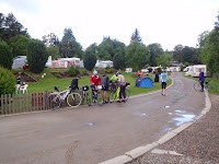
Day started sunny. We were picked up to go to the campsite, and left there about 9:30.


The road climbed for some way then down to Bonar bridge where we had cofee, tea, scone, a mars bar krispi slice and 2 marshmallow chocolate tiffin slices. I missed my caramel slice.


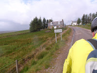
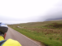
Then it started to rain, increasingly. So we had multiple stops with increasing clothing put on as the rain increased. The wind increased and was gusting sideways. The rain was cold and drenching. We passed by the Falls of Shin but didn't stop, and Cherry got into a singing mode so for the next hour we had her whole repertoire. I pedalled harder to get away from the noise. The road was up and unrelenting. It was grim, the worst so far. We had been told that after the open moor the road went through forest so we were looking forward to a break from the wind, but it had recently been logged so no respite. But the legs and lungs were good. It got grimmer and more buffetting and more desolate, till at 44 miles we came to the only hostelery on the route, the Crask Inn.


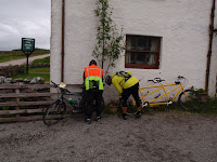
Everyone was there, the bar was full of wet clothes and wet bodies, slurping soup and sitting on the log closed fire to warm up. What a unique place. The owners were slightly doddery and didn't seem in control. In fact they weren't in control. 2 ladies who were camping in the garden (their husbands were climbing Ben Hope) saw the chaos and took over the bar and kitchen. Food flew out to be hoovered up. The soup turned from veg, to pea and ham, to lentil then ran out. The ham sandwiches ran out, the cheese ran out. Only bread remained. But when the mob had left and we remained, the owner produced some of her homemade muffins which we scoffed. Payment was an honour system as no records had been kept. What a great place to find when wet and hungry.


We started again at 4pm with 29 miles to go. The rain had stopped, no sun and still wind. A very short climb to the top of Crask hill, then the highlight of day - 20 miles of ideal tandeming downhill and flat/undulating by a loch and the River Never. We flew, banking round corners. We blew Martin away. Our pedals had wings. Our spirits soared.


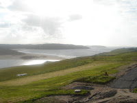
Then it started to rain again, and the wind turned into a headwind. But we had only 7 miles to go, and the seagulls heralded the sea, which we were expecting to see around every corner. Well, we didn't till the very end where we crossed the Never and climbed up to Bettyhill.


 I hestitated to pass the hotel and go down the other side to the campsite, but Cherry being social said we should call in for tea and cakes. It was worth it especially as we could leave our bike and walk back up the hill.
Our room looks out to the front and the beach and sea. Gorgeous. Dinner was problematical with 2 Czech girls who seem to be the only staff in the hotel overwelmed by the crowd, despite us having pre-ordered. Iain's (2 Is) parents came over from their croft just 20 miles away and survived the banter. I fell alseep and had to come up to bed before my bread and butter pudding arrived. Cherry said everyone else enjoyed it.


Then it started to rain, increasingly. So we had multiple stops with increasing clothing put on as the rain increased. The wind increased and was gusting sideways. The rain was cold and drenching. We passed by the Falls of Shin but didn't stop, and Cherry got into a singing mode so for the next hour we had her whole repertoire. I pedalled harder to get away from the noise. The road was up and unrelenting. It was grim, the worst so far. We had been told that after the open moor the road went through forest so we were looking forward to a break from the wind, but it had recently been logged so no respite. But the legs and lungs were good. It got grimmer and more buffetting and more desolate, till at 44 miles we came to the only hostelery on the route, the Crask Inn.


Everyone was there, the bar was full of wet clothes and wet bodies, slurping soup and sitting on the log closed fire to warm up. What a unique place. The owners were slightly doddery and didn't seem in control. In fact they weren't in control. 2 ladies who were camping in the garden (their husbands were climbing Ben Hope) saw the chaos and took over the bar and kitchen. Food flew out to be hoovered up. The soup turned from veg, to pea and ham, to lentil then ran out. The ham sandwiches ran out, the cheese ran out. Only bread remained. But when the mob had left and we remained, the owner produced some of her homemade muffins which we scoffed. Payment was an honour system as no records had been kept. What a great place to find when wet and hungry.


We started again at 4pm with 29 miles to go. The rain had stopped, no sun and still wind. A very short climb to the top of Crask hill, then the highlight of day - 20 miles of ideal tandeming downhill and flat/undulating by a loch and the River Never. We flew, banking round corners. We blew Martin away. Our pedals had wings. Our spirits soared.


Then it started to rain again, and the wind turned into a headwind. But we had only 7 miles to go, and the seagulls heralded the sea, which we were expecting to see around every corner. Well, we didn't till the very end where we crossed the Never and climbed up to Bettyhill.


 I hestitated to pass the hotel and go down the other side to the campsite, but Cherry being social said we should call in for tea and cakes. It was worth it especially as we could leave our bike and walk back up the hill.
Our room looks out to the front and the beach and sea. Gorgeous. Dinner was problematical with 2 Czech girls who seem to be the only staff in the hotel overwelmed by the crowd, despite us having pre-ordered. Iain's (2 Is) parents came over from their croft just 20 miles away and survived the banter. I fell alseep and had to come up to bed before my bread and butter pudding arrived. Cherry said everyone else enjoyed it.


Good Luck for your final day - we expect pictures etc when you get to JOG - heres hoping they do caramel slices there! G xx
ReplyDeleteJust checked again and you are THERE!!!!! What an awesome feeling that must be, my intrepid friends, with muscles and lungs of steel!! What will you do now?!! Can't wait to hear all about it...all our love and huge congratulations!! G xx
ReplyDeleteYay! You've done it! Well done...Can't wait to see you guys at the end of September. Am leaving NZ on Tuesday for Croatia and will let you know when I land on the fair shores of England. xx
ReplyDelete